

Holiday special
Holiday special
In which we get caught in the vortex and look back at the year.

A few things before we get rolling:
Welcome to the new subs! I hope you enjoy your time here in this little corner of the internet.
This will likely be the last post of the year. Don’t tell anyone, but my brain is already on holiday time so we’ll see you next year.
A familiar topic
We’ve talked about weather and climate communication several times in the past, and we’re gonna talk about it now, and I’m sure we’ll talk about it again. It’s sort of why we’re here!
Daniel Swain recently had a post published on Nature.com. The short version is that there needs to be more support for climate researchers to also be climate-communicators.
More climate scientists clearly want to do this work. There is a highly motivated and diverse pool of talented researchers who would make excellent scientist-communicators. I regularly receive messages from early-career scientists, undergraduates and secondary-school students, who ask me how my dual role came to be and how they could fill a similar niche. Yet I struggle to give them specific advice because, at present, there is no clear or replicable path.
Institutional support is the missing piece of the puzzle. Research institutions and funders have often voiced support for increasing public outreach and community engagement by climate scientists. But tangible support has been sparse or non-existent. Public engagement is often treated as secondary to research, teaching and administrative duties. Sometimes these priorities are mentioned explicitly, but often they are indirectly reflected in everything from federal-agency funding calls to performance assessments.
I don’t think I have any more info to add or hot takes to share. It’d just be cool to see things change in this area.
The hurricane season that was
Yale Climate Connections wrote up a summary of the 2023 hurricane season. There’s a focus on the Atlantic but it touches on the Pacific season too. This was the part that I was most interested in hearing about:
There are no great analogs for the current and projected situation of a moderate to strong El Niño combined with a record warm Atlantic,” the team wrote in its August 3, 2023, forecast.
Now we have an answer: The record-warm sea surface temperatures won out, helping the 2023 Atlantic hurricane season finish well above average for storm quantity and accumulated energy, and near average for hurricanes.
Source: https://yaleclimateconnections.org/2023/11/the-unusual-2023-atlantic-hurricane-season-ends/
NCAR’s year in review
The National Center for Atmospheric Research (NCAR) published a recap of their top 5 stories for the year. They included recaps of the articles so I’ll just pick one to share:
While La Niñas are not uncommon, it is rare for the occurrence to repeat for three consecutive winters. Scientists discovered that the catastrophic 2019-2020 Australian bushfires impacted the climate and nudged the Tropical Pacific into a rare multi-year La Niña event.
Time to study
I’ve run into some recent studies/research that seemed worth mentioning. One looked at the jet stream getting faster with climate change. While effects may not be immediately impactful, this is what they found:
"Based on these results and our current understanding, we expect record-breaking winds," said Shaw, "and it's likely that they will feed into decreased flight times, increased clear-air turbulence and a potential increase in severe weather occurrence."
As I mentioned, it’s something we’ll have to keep an eye on for the future.
The scientists said though record-high jet stream wind speeds have been observed in the past decades, the effect is not statistically significant yet. "We would expect the signal to emerge in the next few decades, if humans continue the path we're on with carbon emissions," Shaw said.
There was also a paper about: Do AI models produce better weather forecasts than physics-based models? A quantitative evaluation case study of Storm Ciarán. I’m going grossly simplify things and say no not exactly, and there needs to be more work. It’s still really exciting to see AI and large language models (LLMs) getting applied to forecasting.
Weather West stuff
I’ve missed the last few YouTube sessions but here’s a link to the channel and here’s the last blog post. The blog post was published on the 8th and covers a lot of ground. It’s sort of interesting that he mentions a more active weather pattern for CA starting in ~2 weeks, and guess what? We’re in for several inches of rain over the next few days!
A new blog 🎉
Climate.gov now has a polar vortex blog. It’s going to be similar to the ENSO blog that we read all the time. The initial post is a great place to learn more about the polar vortex and sort of sets the record straight on a few things. I’ll pull a few things I thought were important from the article.
The stratospheric polar vortex forms in the winter hemisphere when the Earth’s pole is pointed away from the sun. The polar stratosphere enters darkness and becomes cold relative to the tropical stratosphere [footnote 1]. The temperature contrast makes for strong winds in the stratosphere that blow from west to east. This wintertime stratospheric wind is what we call the Arctic polar vortex.
Source: https://www.climate.gov/news-features/blogs/polar-vortex/welcome-polar-vortex-blog
And then this image.
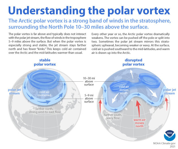
The accompanying caption:
When the Arctic polar vortex is especially strong and stable (left globe), it encourages the polar jet stream, down in the troposphere, to shift northward. The coldest polar air stays in the Arctic. When the vortex weakens, shifts, or splits (right globe), the polar jet stream often becomes extremely wavy, allowing warm air to flood into the Arctic and polar air to sink down into the mid-latitudes. NOAA Climate.gov graphic, adapted from original by NOAA.gov.
Some more reading to get you to next year
Here are a few more things to check out that we couldn’t cover in this post.
Assessing the U.S. climate and global climate in November
From the NWS glossary
I bet this is a new one for you. It sure was for me.
Sastrugi
Ridges of snow formed on a snow field by the action of the wind.
The usuals
Here are your 6-10 day outlooks.


I think we’ll call it there
We covered some good ground in this post so I think we’ll call it a year.
Thank you all so much for reading! Have a great holiday, be well to each other, and we’ll see you on the other side 💙.
I’ll leave you with a few photos of the New Mexico sky.

