


I couldn't eat another bite
In which we talk ground clutter and check our zones.

Just a few things to cover before we jump in. First, welcome to the new subscribers! I hope you enjoy this little piece of the internet we share.
Also, with the holiday season in swing in the U.S., posts may be a little less regular than usual.
On with the show!
Where to start?
We’ve got a lot to choose from this time around so let’s start with the broader picture. The Fifth National Climate Assessment was released. As you can imagine, it covers a lot of ground. For the newsletter, I’ll pull just one of the graphics.
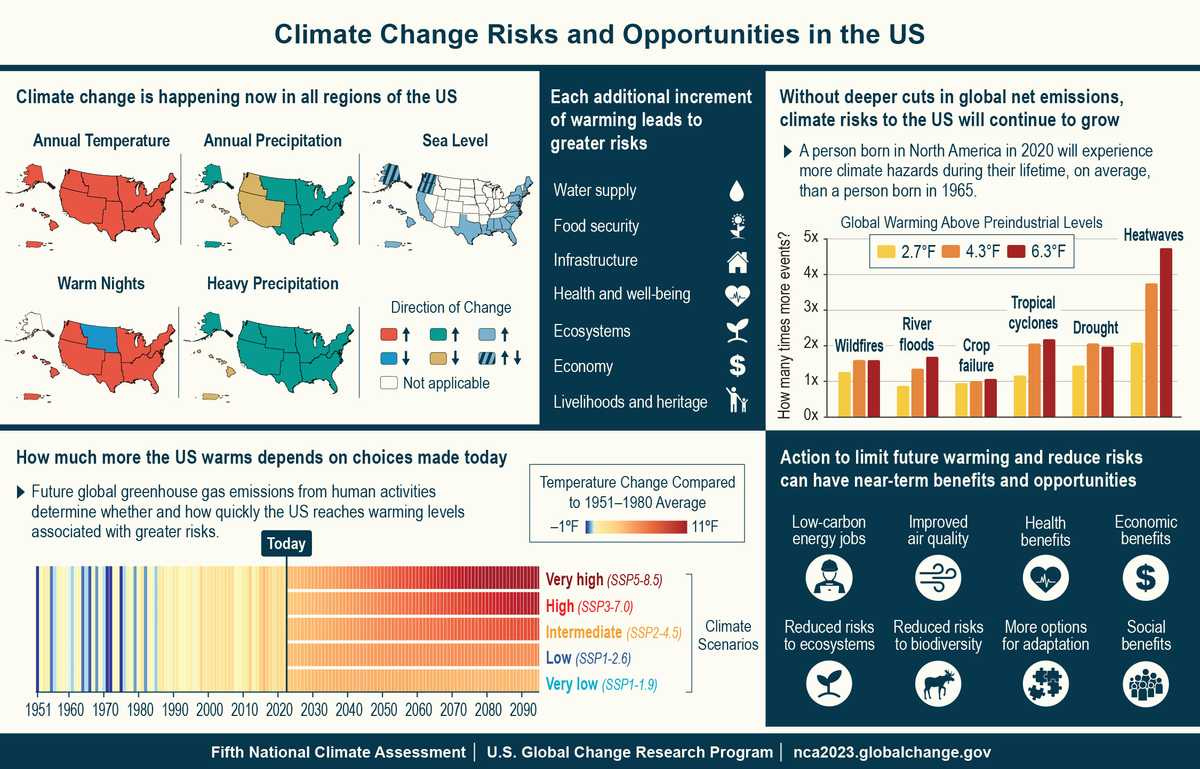
If you want a more thorough review of the report, here you go.
Also, if you’re in the Bay Area, the local NWS office put out a video that’s worth a watch. It covers the winter outlook.
Weather West usuals
I wasn’t able to catch them but here’s the video for the most recent office hours. Swain also published a blog post recently. The post covers the recent cutoff low that impacted California, as well as El Niño. Seems like things might be trending a little wetter come December but we’ll see!
What zone are you in?
If you’re into gardening, you might want to check out the new USDA plant hardiness zone map.
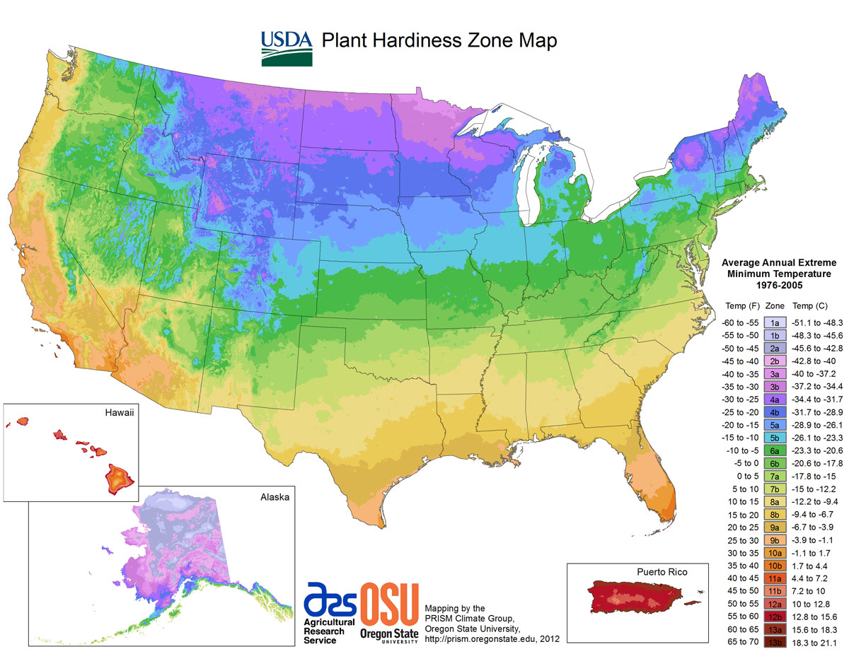
This article talks more about the changes, and you can also toggle between the new map and the one from 2012.
You AIn’t seen nothin’ yet
Please forgive me, I promise that’ll be the last AI pun.
There’s been a bit more activity in the weather + climate + AI space since the last time we mentioned it. First up, Google DeepMind introduced GraphCast. As you might expect, it’s meant to increase forecast accuracy with less computing power. There was a detailed article on how it predicted that hurricane Lee would hit Nova Scotia 3 days earlier than other approaches. This is obviously exciting, but I thought this quote was worth mentioning.
"Weather forecasts derived from artificial intelligence and machine learning are taking huge leaps forward," acknowledges Prof Simon Vosper, the Met Office's Director of Science.
But he warns climate change will limit the predictive power of AI based tools.
"We are seeing new climate-related weather extremes, such as last year's 40C temperatures in the UK that would haven't been realised in former times", says Prof Vosper.
Source: https://www.bbc.com/news/science-environment-67383755
Many of these AI forecast approaches are trained on historical data, and don’t try to simulate the atmosphere to predict the weather the way existing models do. That means…
"So it is fair to question whether AI-based systems are able to pick up new extremes if these systems have only been 'trained' on previous weather conditions," suggests Prof Vosper.
Source: https://www.bbc.com/news/science-environment-67383755
Either way, it’s an exciting time at the intersection of weather and technology! If you want to read more about GraphCast and some of the other stuff that’s been going on, this WaPo article and this post from The Met Office are both solid.
Hey, that’s me!
Before we totally move on from AI, I thought I’d share something I’ve been tinkering with to learn more about AI and large language models (LLMs).
The video illustrates a rough take on a weather chatbot + app. I used Retool Vectors to provide NWS glossary terms and some historical hurricane writeups to the model for the chatbot portion. The forecast "rewriter" uses a prompt I wrote to reformat and edit raw NWS forecast discussions. Definitely not perfect but a lot of fun to chip away at.
I also had a good laugh at this. I had AI generate an image of a “home weather station” and this is what it generated.

Asperitas clouds
These are some fairly rare cloud formations. I don’t think I’ve ever seen them, but they might be worth a quick Google search if you want to see more. They’re super cool.

El Niño updates
We covered this in the last newsletter but the video below does a nice job of explaining what’s going on with El Niño too.
From the NWS glossary
This time around, G is for “ground clutter”.
Ground Clutter
A pattern of radar echoes from fixed ground targets (buildings, hills, etc.) near the radar. Ground clutter may hide or confuse precipitation echoes near the radar antenna.
The usuals
Here are your 6-10 day outlooks, 3 day convective outlooks, and the drought monitor.


https://www.spc.noaa.gov/products/outlook/
https://www.cpc.ncep.noaa.gov/products/predictions/610day/
That’s it for now
See you next time, weather fam! I’ll leave you with a few mini-rainbow photos. The powerlines were a bummer but it was still fun to see.


I have seen those clouds only once.